Remark
Please be aware that these lecture notes are accessible online in an ‘early access’ format. They are actively being developed, and certain sections will be further enriched to provide a comprehensive understanding of the subject matter.
2.1. Introduction to GIS#
A Geographic Information System (GIS) is a robust tool that enables users to capture, store, analyze, manage, and visualize data tied to geographical locations. It combines the science of geography with information system technology, providing insights and solutions to complex spatial data-related questions [Böhner et al., 2014, Kumar et al., 2023].
2.1.1. The Science and Technology of GIS#
Geographic Information Systems (GIS) integrate hardware, software, and data to capture, manage, analyze, and visualize geographically referenced information. This integration deepens our understanding of spatial data, enabling users to [Kumar et al., 2019, Wieczorek and Delmerico, 2009]:
Capture: Leverage advanced hardware like satellites, drones, and sensors to collect accurate geographical data.
Manage: Use sophisticated software to efficiently store, retrieve, and organize large volumes of spatial information.
Analyze: Examine spatial relationships, patterns, and trends using powerful analytical tools that process and interpret data.
Display: Make complex geographical data accessible to a wide audience by presenting it intuitively through maps, globes, reports, and charts.
GIS technology allows users to interpret and represent data in multidimensional ways, revealing complex relationships, uncovering hidden patterns, and identifying emerging trends. It’s a fusion of science and technology that transforms raw data into actionable insights, promoting informed decision-making across various disciplines.
2.1.2. Components of a GIS#
A Geographic Information System (GIS) consists of several key components that work together [Management Association, 2016]:
Hardware: The physical infrastructure of a GIS, ranging from high-performance servers for processing large datasets to mobile devices and GPS units for field data collection.
Software: A set of tools that facilitate the recording, analysis, and presentation of spatial data. This includes robust desktop applications like QGIS and ArcGIS, as well as versatile web-based platforms and mobile apps.
Data: The heart of GIS, spatial data includes everything from satellite imagery and topographic maps to demographic statistics and environmental attributes.
People: Standardized protocols and procedures that ensure data accuracy, consistency, and reliability across various GIS projects and applications.
Methods: Standardized protocols and procedures that ensure data accuracy, consistency, and reliability across various GIS projects and applications.
Fig. 2.1 illustrates the interconnected components of a GIS, including data collection, hardware, software, people, and methods, highlighting the cyclical nature of GIS operations.
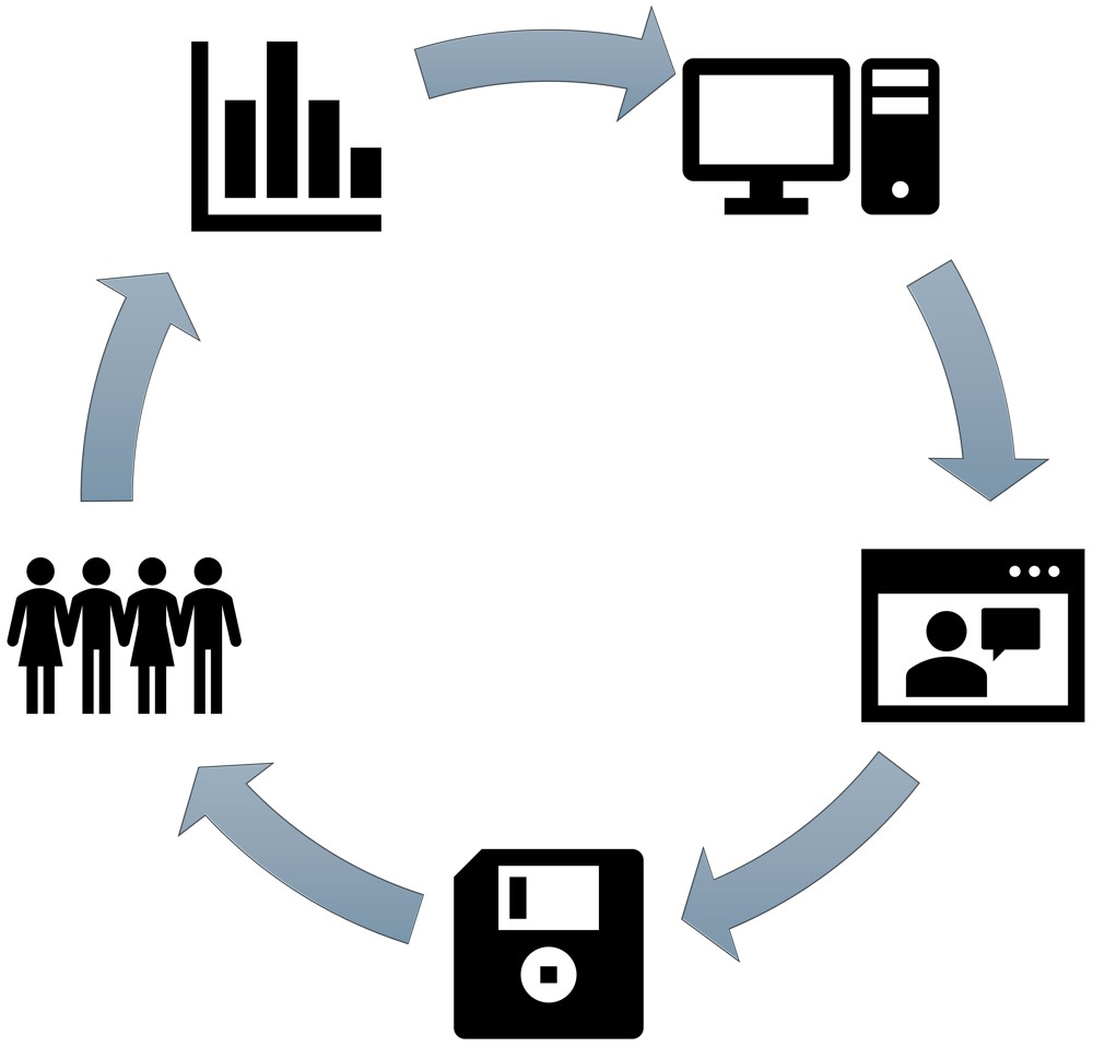
Fig. 2.1 Components of a Geographic Information System (GIS)#
2.1.3. Functions of a GIS#
GIS technology is multifaceted, performing several critical functions:
Mapping: GIS mapping extends beyond traditional cartography to include interactive web maps, 3D terrain models, and real-time data visualizations [Li and Yang, 2021].
Analysis: GIS conducts complex spatial analyses, such as predictive modeling, network analysis, and multivariate statistics, revealing patterns and trends [Haldar, 2013].
Data Management: It serves as a comprehensive framework for storing, retrieving, and updating spatial data, with the spatial component acting as a unifying index [Reddy, 2018].
Integration: GIS integrates diverse data types, combining spatial data with business intelligence, sensor networks, and multimedia to provide a comprehensive view [Vacca, 2022].
2.1.4. Spatial Analysis#
Spatial Analysis is a core process in Geographic Information Systems (GIS) that involves studying the positions, attributes, and relationships of features in spatial data. It applies analytical algorithms to interpret geographic patterns, trends, and connections within their spatial context [Dolins et al., 2021].
2.1.4.1. What Spatial Analysis Entails:#
Pattern Identification: This involves identifying and understanding the spatial distribution of features.
Example 2.1
In public health, spatial analysis can be used to identify clusters of disease cases, such as mapping the spread of COVID-19 to determine hotspots and allocate resources effectively. In ecology, it can help understand the dispersion of wildlife habitats to inform conservation efforts [Jerrett et al., 2003, Rushton, 2003].
Spatial Relationships: This involves determining how different locations relate to each other, including proximity, adjacency, and accessibility.
Example 2.2
In urban planning, spatial analysis can be used to assess the accessibility of public services like hospitals and schools by analyzing the proximity of these facilities to residential areas. This helps in making decisions about where to build new infrastructure [Walker et al., 2021, Yao et al., 2021].
Trend Analysis: This involves monitoring changes over time to predict future occurrences or understand past patterns.
Example 2.3
In environmental studies, spatial analysis can track deforestation over time by analyzing satellite imagery, helping predict future forest loss and assess the impact of conservation policies. In urban studies, it can be used to analyze urban expansion patterns to guide sustainable city planning [Cillis et al., 2021, Nuthammachot and Stratoulias, 2021].
Optimization: This involves finding the most efficient routes for logistics, the best locations for new facilities, or the optimal layout for land use planning.
Example 2.4
In logistics, spatial analysis can optimize delivery routes to minimize travel time and reduce fuel consumption. In retail, it can help determine the best locations for new stores by analyzing factors such as population density and competitor locations [Jeong et al., 2021, La Guardia et al., 2022].
2.1.5. Applications of GIS#
Geographic Information Systems (GIS) technology is crucial across multiple sectors. Here are some specific applications:
Environmental Management: GIS plays a key role in monitoring deforestation in the Amazon, analyzing the impact of climate change on polar ice caps, managing water resources in arid regions, and coordinating responses to natural disasters like hurricanes and wildfires [Nekhay et al., 2009, Viña et al., 2010].
Urban Planning: Planners use GIS to design public transportation routes, manage urban sprawl, optimize utility networks, and develop smart city initiatives that integrate data from various sensors and sources [Jat et al., 2008, Tv et al., 2012].
Public Health: Public health officials use GIS to track the spread of infectious diseases like COVID-19, optimize the location of healthcare facilities, and analyze public health data to identify at-risk populations and direct resources effectively [Cordes and Castro, 2020, Franch-Pardo et al., 2020].
Business: Companies leverage GIS for retail site selection, conducting market analysis to identify potential customer bases, optimizing logistics to reduce delivery times, and enhancing supply chain management to avoid disruptions [Zhu et al., 2015].
GIS serves as a critical platform for data visualization, spatial analysis, and strategic planning. It underpins the burgeoning field of geospatial data analytics, providing insights that are spatially anchored and contextually rich. Mastery of GIS opens doors to a world where data is not just numbers, but a landscape of information.