Remark
Please be aware that these lecture notes are accessible online in an ‘early access’ format. They are actively being developed, and certain sections will be further enriched to provide a comprehensive understanding of the subject matter.
1.2. What is Remote Sensing?#
Remote sensing is a technique used to gather information about objects or areas from a distance, typically from aircraft or satellites. It’s a critical tool in Earth sciences, environmental monitoring, and many other fields [Earth Science Data Systems, 2019, Natural Resources Canada, 2007].
1.2.1. Components of Remote Sensing#
Remote sensing is a fascinating field that involves capturing and analyzing information about objects or areas from a distance, typically using satellites or aircraft. The selected text you’ve provided outlines the journey of electromagnetic radiation in remote sensing applications, which includes several key components [Natural Resources Canada, 2007]:
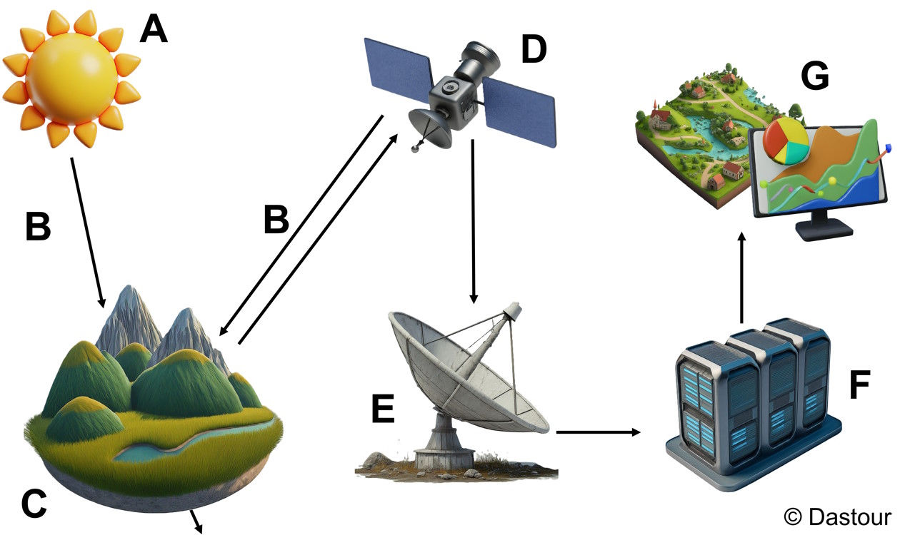
Fig. 1.1 The illustration demonstrates the journey of electromagnetic radiation from its source to its ultimate use in remote sensing applications. Image reproduced based on the idea presented in [Natural Resources Canada, 2007].#
A. Energy Source: The primary energy source for remote sensing is the sun. Electromagnetic radiation emitted by the sun travels through space and reaches the Earth’s atmosphere. Some remote sensing systems also use artificial sources of energy, such as lasers in LIDAR (Light Detection and Ranging) systems [Natural Resources Canada, 2007].
B. Atmosphere: As electromagnetic energy travels through the Earth’s atmosphere, it interacts with atmospheric particles and gases. This interaction can lead to scattering, absorption, and reflection, which may affect the quality and characteristics of the energy reaching the Earth’s surface and the sensors. Atmospheric conditions can influence the accuracy and clarity of the remote sensing data {cite}`canada_remote_2007.
C. Target Interaction: The interaction of electromagnetic energy with a target on the Earth’s surface depends on the target’s material properties, surface roughness, and the wavelength of the energy. Different materials reflect, absorb, and emit electromagnetic energy differently. For instance, healthy vegetation absorbs most visible light but reflects near-infrared light, making it appear green to human eyes and distinct in infrared images [Natural Resources Canada, 2007].
D. Sensors: Sensors are devices that detect and measure the energy reflected or emitted from the Earth’s surface. They can be mounted on various platforms, including satellites, aircraft, drones, and ground-based stations. Sensors vary in their capabilities, such as spectral resolution (the ability to distinguish different wavelengths of energy), spatial resolution (the size of the area on the ground that each pixel represents), and temporal resolution (how often data is collected for the same area) [Natural Resources Canada, 2007].
E. Transmission, Reception, and Processing: Once the sensors collect data, it is transmitted to ground stations for processing. This transmission can occur via radio waves or other communication methods. The received data undergoes processing, which includes correcting any distortions, calibrating the sensor data, and converting the raw data into interpretable images or numerical values. Advanced algorithms and software tools are used to enhance the data quality and extract relevant information [Natural Resources Canada, 2007].
F. Interpretation and Analysis: Specialists, such as remote sensing analysts, geographers, and environmental scientists, interpret and analyze the processed data to extract meaningful information. This step involves identifying patterns, anomalies, and trends within the data. For example, analysts might assess the health of vegetation, detect changes in land use, or monitor the extent of natural disasters [Natural Resources Canada, 2007].
G. Application: The information derived from remote sensing is used in various applications, including weather forecasting, urban planning, environmental management, and military surveillance [Natural Resources Canada, 2007].
These components work together to provide valuable insights into the Earth’s surface and atmosphere, which can be used for a wide range of practical applications.
1.2.2. Applications of Remote Sensing#
Remote sensing is a transformative approach that significantly enhances our understanding and interaction with the planet. It has a broad spectrum of applications, as detailed below [Hassan, 2023, Natural Resources Canada, 2007, U.S. Geological Survey, 2024]:
Environmental Monitoring: Essential for observing deforestation, pollution levels, and climate change effects. It detects changes in land cover and vegetation, indicating environmental stress or degradation [Dastour et al., 2024, Dastour and Hassan, 2024].
Agriculture: Crucial for assessing crop health, analyzing soil conditions, and guiding agricultural practices. The Normalized Difference Vegetation Index (NDVI) provides critical information on vegetation health, aiding precision agriculture [Huang et al., 2018, Weiss et al., 2020].
Oceanography: Enhances the study of ocean currents, marine biodiversity, and water quality. Tracks sea surface temperatures and color, assisting in fisheries management [Devi et al., 2015, Rajeesh and Dwarakish, 2015].
Geology: Vital for mapping mineral deposits, fault lines, and geological formations, enriching our knowledge of Earth’s structure and resources [Gupta, 2017, van der Meer et al., 2012].
Disaster Management: Invaluable for monitoring natural disasters like floods, earthquakes, and forest fires, offering essential data for emergency response and recovery efforts [Dastour and Hassan, 2024, Rahman and Di, 2017, Sanyal and Lu, 2004].
These applications highlight the versatility of remote sensing and its importance in providing critical data for informed decision-making across various sectors.
1.2.3. Active and Passive Remote Sensing#
Active and passive remote sensing are the two primary methodologies employed in the observation of Earth’s surface and atmosphere. Each method utilizes different sources of energy to capture data, which is crucial for various environmental and scientific applications [Earth Science Data Systems, 2019, Natural Resources Canada, 2007].
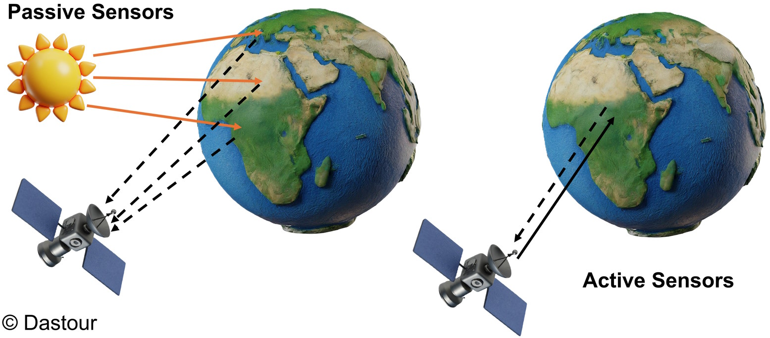
Fig. 1.2 Diagram of a passive sensor compared to an active sensor.#
1.2.4. Active Remote Sensing: Harnessing Energy to Observe the Earth#
Active remote sensing systems are remarkable for their ability to emit pulses of energy, which interact with the Earth’s surface and return to the sensor. This self-sufficiency in energy emission enables them to operate effectively under any lighting conditions, including nighttime or cloudy skies. These systems primarily function in the microwave portion of the electromagnetic spectrum, allowing them to penetrate the atmosphere reliably [Earth Science Data Systems, 2019, Natural Resources Canada, 2007].
Key types of active remote sensing include [Earth Science Data Systems, 2019, Natural Resources Canada, 2007]:
Radar: An active radio detection and ranging sensor that emits microwave radiation in pulses. The reflected energy from targets is captured and measured, providing valuable data for creating two-dimensional surface images. Radar technology is crucial for applications such as weather forecasting, navigation, and speed enforcement.
LiDAR (Light Detection and Ranging): A sensor that uses a laser to transmit light pulses and sensitive detectors to measure the backscattered light. The time difference between the transmitted and backscattered pulses, combined with the speed of light, is used to calculate distances, contributing to precise topographical surveys and 3D terrain models.
Sonar: A system that employs sound waves to detect and communicate with objects underwater. It is essential for submarine navigation, marine biology research, and exploring aquatic environments.
Active sensors like laser altimeters and scatterometers are also integral to remote sensing, providing detailed measurements of the Earth’s surface. These instruments measure the height of platforms above the surface and the backscattered radiation over oceans, respectively, aiding in the understanding of surface wind speeds and directions.
The Fig. 1.3 represents the fundamental operation of an active remote sensing system [Earth Science Data Systems, 2019]:
Satellite: Represents the active sensor platform, typically in orbit around the Earth.
Emission of Energy Signals: The solid arrow from the satellite to the Earth signifies the transmission of energy, such as radio waves or laser pulses, towards the Earth’s surface.
Interaction with Earth’s Surface: The energy signals interact with the surface, which could involve reflection, scattering, or absorption.
Reception of Reflected Energy: The dashed arrow pointing back to the satellite indicates the collection of the energy that has bounced back after interacting with the Earth’s surface.
This process allows the active remote sensing system to gather data about the Earth’s surface, such as topography, vegetation, and other features, regardless of lighting conditions or cloud cover. The data collected is then used for various analyses, including environmental monitoring, mapping, and resource management.
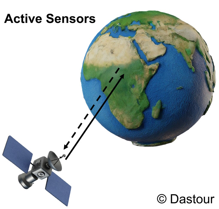
Fig. 1.3 Illustration of an active remote sensing system, depicting the emission and reception of energy signals for Earth surface analysis.#
1.2.5. Passive Remote Sensing: Capturing Earth’s Natural Emissions#
Passive remote sensing systems are adept at capturing the energy naturally emitted or reflected by the Earth’s surface. These systems are solar-powered detectives, relying on the sun as their primary source of radiation. Consequently, passive sensors are most effective during daylight when the sun’s rays are ample. They operate across various segments of the electromagnetic spectrum, including the visible, infrared, thermal infrared, and microwave bands [Earth Science Data Systems, 2019, Natural Resources Canada, 2007].
Some examples of passive remote sensing instruments [Earth Science Data Systems, 2019, Natural Resources Canada, 2007]:
Photographic Cameras: These devices record images by capturing light within the visible spectrum. They can utilize traditional photographic film or modern digital sensors and are the cornerstone of conventional aerial photography.
Multispectral Scanners: These scanners are tuned to detect energy within specific wavelength bands of the electromagnetic spectrum. This capability allows for the discernment of different surface materials and conditions, making them versatile tools in Earth observation.
Hyperspectral Imagers: With the ability to collect data across an extensive range of wavelengths, hyperspectral imagers provide a wealth of spectral information for each image pixel. This detailed data is crucial for applications such as mineral detection, agricultural management, and environmental surveillance.
The Fig. 1.4 represents a passive remote sensing system, which operates by detecting the natural energy emitted or reflected from the Earth’s surface [Earth Science Data Systems, 2019]:
Earth: Shown with a day and night side, illustrating that passive sensors can collect data during daylight when solar illumination is available.
Natural Emissions: The orange lines originating from the Earth’s surface represent the energy naturally emitted or reflected, which can be in the form of visible light, heat, or other electromagnetic radiation.
Passive Sensors Satellite: The satellite labeled “Passive Sensors” is equipped with instruments that detect this natural energy without emitting any signals of its own.
Solar Radiation: The yellow arrows from the sun to the Earth indicate the source of illumination for passive sensing, highlighting the dependency on external light sources.
This passive sensing method is essential for monitoring environmental conditions, assessing vegetation health, and other applications where natural light is used to observe and measure various characteristics of the Earth’s surface.
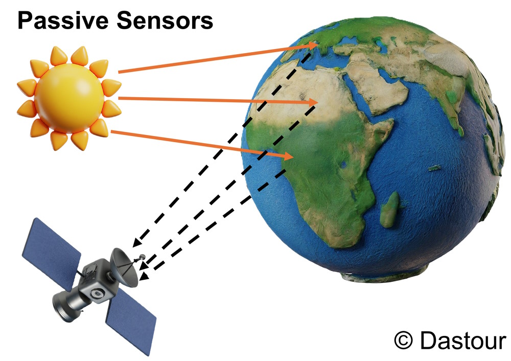
Fig. 1.4 Illustration of an passive remote sensing system capturing the natural emissions of the Earth.#
1.2.6. Choice between Active and Passive Remote Sensing#
The choice between active and passive remote sensing technologies is dictated by the specific requirements of the task at hand. While active sensors offer the advantage of consistent data collection regardless of time or weather, passive sensors benefit from the rich spectral information provided by sunlight. Often, a combination of both active and passive sensing is used to gain a comprehensive understanding of an area, leveraging the strengths of each method to enhance data quality and interpretation.
1.2.7. Resolution of Remote Sensing Images#
There are four key types of resolution that are essential to consider:
Radiometric Resolution: This defines the sensor’s ability to distinguish different levels of energy (This will be discussed in Section 1.3).
Spatial Resolution: This determines the smallest detail that can be observed on the ground (This will be discussed in Section 1.4).
Spectral Resolution: This identifies the specific wavelength bands that the sensor can detect (This will be discussed in Section 1.5).
Temporal Resolution: This measures how frequently the satellite revisits the same location (This will be discussed in Section 1.6).
Each type of resolution provides unique insights and plays a significant role in interpreting remote sensing data. In the following sections, we will discuss each type in detail.