Remark
Please be aware that these lecture notes are accessible online in an ‘early access’ format. They are actively being developed, and certain sections will be further enriched to provide a comprehensive understanding of the subject matter.
1.6. Temporal Resolution#
Temporal resolution is a critical aspect of remote sensing that determines how frequently a satellite can capture images of the same location on Earth. Higher temporal resolution means more frequent observations, allowing us to observe changes over time with greater detail [Richards, 1986, Natural Resources Canada, 2007].
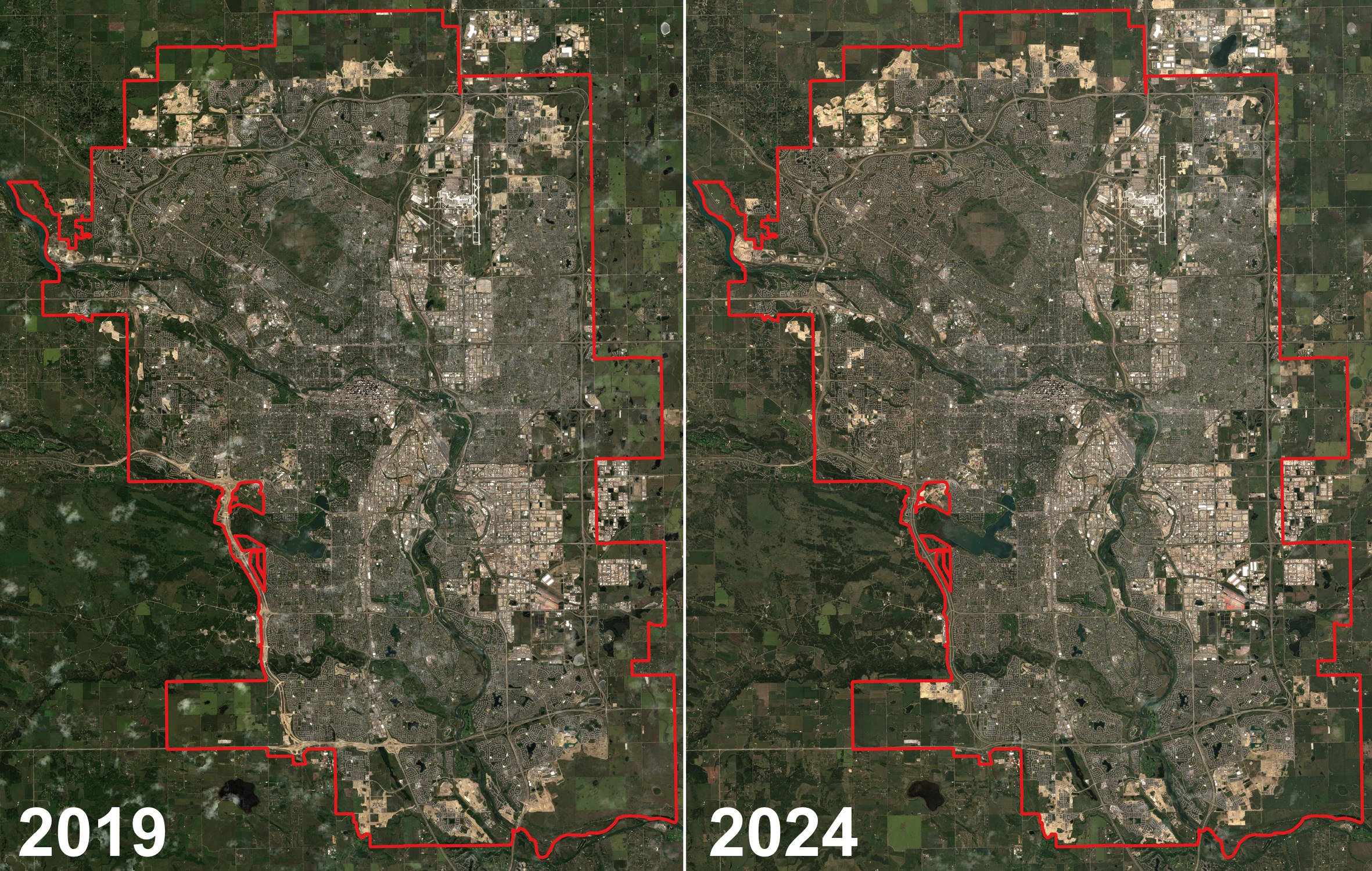
Fig. 1.20 Left and right panels demonstrate the Red, Blue, and Green bands of Harmonized Sentinel-2 MSI: MultiSpectral Instrument, Level-2A. The images compare land use and vegetation changes between 2019 and 2024 in the city of Calgary. The red overlayed polygon represents the official city boundary in 2024. This visualization highlights urban development and environmental changes over the five-year period. Image processed by H. Dastour using Google Earth Engine. Note: JPG format for web display and the image processed by H. Dastour using Google Earth Engine.#
Fig. 1.20 provides a visual comparison of the city of Calgary using satellite imagery from the Harmonized Sentinel-2 MultiSpectral Instrument (MSI), Level-2A [Agency, 2024]. The left panel shows the city as it appeared in 2019, while the right panel shows the city in 2024. Both images utilize the Red, Blue, and Green spectral bands, which are commonly used to create natural color images that closely resemble what the human eye would see. The red polygon overlay represents the official city boundary of Calgary as of 2024. This boundary helps to contextualize the urban development and expansion over the five-year period. By comparing the two panels, one can observe changes in land use, such as new developments, changes in vegetation cover, and other environmental changes. These changes are crucial for urban planning, environmental monitoring, and resource management.
1.6.1. Understanding Temporal Resolution#
Temporal resolution is analogous to having a time-lapse camera in space. It defines the interval between consecutive images taken by a satellite of the same area.
Example 1.14 (High vs. Low Temporal Resolution)
High Temporal Resolution: A satellite with a temporal resolution of one day can provide daily images of an area. This allows for monitoring daily changes, such as weather patterns or traffic flows.
Low Temporal Resolution: A satellite with a temporal resolution of one month provides images once a month. This is suitable for observing slower processes, like seasonal vegetation growth or urban development.
Fig. 1.21 illustrates the concept of temporal resolution in remote sensing. Temporal resolution refers to how frequently a satellite can revisit and capture data from the same location on Earth’s surface. In the image, two satellites are shown orbiting above the Earth, with their paths intersecting over a specific area. This intersection indicates that the satellites are capturing images or data from this point at different times. The ‘X’ pattern formed by their orbits suggests multiple passes over the same region, allowing for the monitoring of changes over time. Higher temporal resolution means more frequent data collection, which is crucial for applications like environmental monitoring, disaster management, and agricultural planning, where observing changes over time is essential.
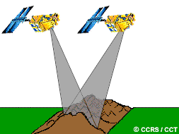
Fig. 1.21 The concept of temporal resolution in satellite remote sensing. Image Credit: [Natural Resources Canada, 2007]. Link to the image.#
1.6.2. Importance in Emergency Situations#
The importance of temporal resolution is particularly evident during natural disasters. Satellites with high temporal resolution can offer frequent updates, helping responders track the spread of the disaster and plan their interventions more effectively.
Example 1.15 (Monitoring Natural Disasters)
Floods: High temporal resolution satellites can monitor the progression of floods, providing crucial data for evacuation and relief efforts [Lopez et al., 2020, Munawar et al., 2022].
Wildfires: Frequent imaging helps track the spread of wildfires, aiding in resource allocation and firefighting strategies [Dastour and Hassan, 2024, Gale et al., 2021].
1.6.3. Role in Environmental Monitoring#
Temporal resolution is vital for long-term environmental monitoring. It enables scientists to study phenomena such as climate change, deforestation, and agricultural production by providing consistent data over time, which is essential for identifying trends and making predictions.
Example 1.16 (Observing Climate Change)
Deforestation: High temporal resolution imagery can track deforestation rates, helping to assess the impact of conservation efforts [Chaddad et al., 2022].
Agricultural Production: Regular monitoring of crop growth and health over growing seasons can improve agricultural practices and yield predictions [Weiss et al., 2020].
1.6.4. Temporal Resolution in Practice#
Temporal resolution is about the rhythm and frequency of satellite visits to a specific area, providing a dynamic view of our planet’s surface and the changes it undergoes. It enhances our ability to understand and respond to both rapid and gradual changes on Earth.
Example 1.17 (Satellite Missions)
MODIS (Moderate Resolution Imaging Spectroradiometer): MODIS provides daily global coverage, making it ideal for monitoring rapid environmental changes such as wildfires, floods, and deforestation. Its high temporal resolution allows for near real-time observation and analysis.
Landsat: With a 16-day repeat cycle, Landsat is valuable for studying slower processes like land use changes, vegetation growth, and urban development. The long-term data record from Landsat satellites, which spans over 50 years, is crucial for understanding long-term environmental trends and changes.